


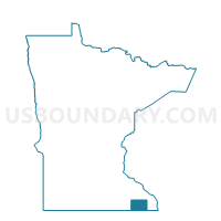
Preble Twp. Voting District, Fillmore County, Minnesota
About
Outline

Summary
| Unique Area Identifier | 601929 |
| Name | Preble Twp. Voting District |
| County | Fillmore County |
| State | Minnesota |
| Area (square miles) | 35.75 |
| Land Area (square miles) | 35.75 |
| Water Area (square miles) | 0.00 |
| % of Land Area | 100.00 |
| % of Water Area | 0.00 |
| Latitude of the Internal Point | 43.63058830 |
| Longtitude of the Internal Point | -91.79035920 |
Maps

Graphs
Select a template below for downloading or customizing gragh for Preble Twp. Voting District, Fillmore County, Minnesota


Neighbors
Neighoring Voting District (by Name) Neighboring Voting District on the Map
- Amherst Twp. Voting District, Fillmore County, MN
- Black Hammer Twp. Voting District, Houston County, MN
- Canton Twp. Voting District, Fillmore County, MN
- Holt Twp. Voting District, Fillmore County, MN
- Newburg Twp. Voting District, Fillmore County, MN
- Norway Twp. Voting District, Fillmore County, MN
- Spring Grove Twp. Voting District, Houston County, MN
- Yucatan Twp. Voting District, Houston County, MN
Top 10 Neighboring County Subdivision (by Population) Neighboring County Subdivision on the Map
- Canton township, Fillmore County, MN (724)
- Spring Grove township, Houston County, MN (402)
- Newburg township, Fillmore County, MN (379)
- Amherst township, Fillmore County, MN (378)
- Norway township, Fillmore County, MN (343)
- Yucatan township, Houston County, MN (323)
- Holt township, Fillmore County, MN (271)
- Black Hammer township, Houston County, MN (245)
- Preble township, Fillmore County, MN (209)
Top 10 Neighboring Unified School District (by Population) Neighboring Unified School District on the Map
- Rushford-Peterson Public Schools, MN (4,052)
- Mabel-Canton Public School District, MN (2,475)
- Lanesboro Public School District, MN (1,702)
Top 10 Neighboring State Legislative District Lower Chamber (by Population) Neighboring State Legislative District Lower Chamber on the Map
Top 10 Neighboring State Legislative District Upper Chamber (by Population) Neighboring State Legislative District Upper Chamber on the Map
Top 10 Neighboring 111th Congressional District (by Population) Neighboring 111th Congressional District on the Map
Top 10 Neighboring Census Tract (by Population) Neighboring Census Tract on the Map
- Census Tract 209, Houston County, MN (3,883)
- Census Tract 9604, Fillmore County, MN (3,136)
- Census Tract 9606, Fillmore County, MN (3,125)
- Census Tract 203, Houston County, MN (2,561)
Top 10 Neighboring 5-Digit ZIP Code Tabulation Area (by Population) Neighboring 5-Digit ZIP Code Tabulation Area on the Map
- 55943, MN (3,059)
- 55974, MN (2,132)
- 55949, MN (1,808)
- 55954, MN (1,442)
- 55922, MN (1,021)
- 55962, MN (763)